Iran Deserts
Iran Deserts
Lout & Central Desert of Iran
Iran Deserts: Around one fourth of Iran consist of Desert Regions, having been placed amongst the Northern Mountains or Alborz & the Central Range & the Eastern Mounts; the most famous of which, are Deserts of Lout & Kavir(360.000 km2).
In Iran, the Desert Regions, are devided into Central Desert, Small Desert, Rig-e Jen Desert, & Lout Desert.
Lout Plain: IN Geographical wrights, Dasht-e Lout has been named Chale/ Puddle of Lout, or Lout Plain; due to some similarities with Kavir Plain, amongst the masses it’s named Kavir/ Desert of Lout.
Lou Desert, a range between the provinces of South Khorasan, Sistan & Baluchestan, plus Kerman, has been placed between the Faults of Nehbandan in East & Nayband in West; the length of which from North to South is about 900 km, & from West to East around 300 km. The area of Lout Plain basin catchment, is around 175000 km2, equal to one tenth of the country area.
The first theory of geothermal pole in Lout, was introduced by professor Estratil of Vienna University, Austria. After air researches, he introduced the West of Nosrat Abad on Rig-e Yalan, as the warmest spot of the Earth. In the next years, that same place was confirmed as the Earth geothermal pole.
According to Nasa recorded map, on 2003, the highest recorded temperature (70.3 degree of centigrade) has been that of Rig-e Yalan, East of Lout. This temperature, was not repeated again, but from that year on(up to 2009) this spot has had the highest temperature of the Earth.
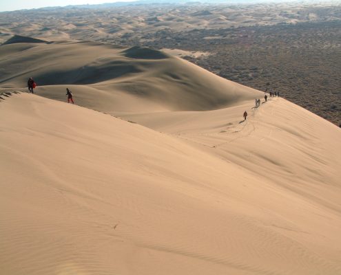
Lout Plain, is a vast sandy Desert, encompassing several local basins; every one of which, receive the Surface runoffs of the environs; in inner parts or margins & or in some parts of seasonal/ temporary currents of which, desert fields has been shaped. Generally, comparing to sandy lands, the vastness of Desert in Lout Plain is not that much large; according to which, Lout Desert is quite in contrast with Kavir Plain, consisting mostly of Desert. Therefore as the geographical researches have frequently confirmed, the name of Lout Desert, applied for this region has not been correct, but the name Lout Plain(Geomorphology of Iran, Qumes publication, by Mahmud Ala’ee Taleqani, 1386).
Some works of Human settlement from the Forth Millennium, at the foot of dominated Mounts over Lout Desert have been observed(Shahdad & Historical Geography of Lout Plain, by Dr. Ahmad Mostowfi, 8th publication of Geographical reports, Dey Month of 1351).
Upon nominating this plain, there is no consensus. In an description by Mohammad-Ibn-e Ebrahim, the flee of Qazha retinue, named Lout, has been implied to; also applying to the imaginary town of kalouts. As a result, in the past times, not the whole present Lout Desert has been named Lout, but a part of it.
With no imply to any source, “Sir Persi Sixe” has mentioned that Lout, has been derived of the prophet Lout, son of the prophet Ibrahim brother. The description of Lout Nomad land, in Qoran & Torah, is so similar to Lout Desert; after Lout prophet Curse of which, has become a dry and barren land.
On the other hand, in Turkish Language, the term “Lout” means naked and without anything.
Attractions:
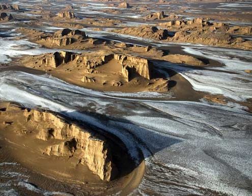
– Kalouts: As a local term, Kalout is applied to very huge ditches, shaped out of waters & winds erosion. Remotely, the region of Kalouts, looks like the ruins of a big city; the other name of which is the adobe Town.
– High Sandy Pyramids: In Lout, sometimes the height of some pyramids, reaches to
480 m.
– Volcano Cone: There are 40 cones of Ko’aterner Volcano in Lout Plain.
– Camel Toe Desert: These lands have the surface, as if wetted after a lot of rain fall, they have been stepped by several camels.
– Hammada: They are the plains covered by sandy soils, with no plants.
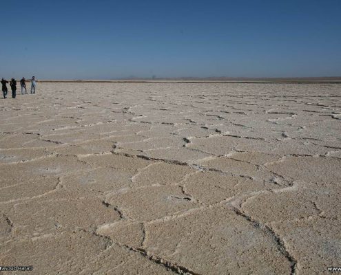
– Areas, in the shape of several polygons, shaped out of a thick salty layer & intense evaporation of earth surface.
– Vast sandy areas, with color spectrum of bright brown to grey & black, like: “Barut Godar/ gunpowder pass
The vegetation: Around 20 km from Shahdad, the trees & shrubs of Gaz, have been grown in Lout desert vases, named Nebka or Plant Hills.
The lands, in between Nebkas, are sand-covered. Generally on even surfaces, with average sand level & high underground water level, along with sufficient moisture, the Nebkas are appeared; shaped out of sand, mud, clay, & celts.
Several year old & permanent Nebkas, have the key role over the level of underground water change, wasted waters, evaporation, transpiration and control of wind sediments.
With bigger dimensions, Rebdous, are separated from Nebkas; with the length & width of 2-7 m & 1-5 m, respectively. Except for the dimensions, Rebdous are more complicated than Nebkas, in their form & some times, show several cones, set beside each other. The highest Rebdous are seen in West Lout; the height of which, sometimes reaches to 12 m.
Kavir Plain:
Having been placed at the Iran Flat center, Central Desert(800 km in length, & 600 km in width), also named Chale/puddle of Desert & or Salt Desert, is limited from North to the domains of Central & Eastern Alborz, from West to the Link road of Damqan- Jandaq & Rig-e Jen desert, from East to the Mounts of Pir-e Hajat & Uzbek & from South to contact axis of Khur- Tabas. The most parts of this plain is covered by vast swamps & in the margins, by the sandy hills & scattered heights; the dominant flora of which is generally Halophyte. It’s also considered as one of the thermal poles of the earth; in summer the temperature of which, reaches to 50 degree centigrade; sometimes the difference of day & night temperature of which, reaches to 70 degree centigrade.
National Park of kavir, & that of deserts of Kharturan, Bejestan, Haj Ali Qoli (Damqan), Masile, Maranjab, & Band-e rig are all stationed in this region; the name of which is adapted from its vast desert.
It’s not exactly clear, to which era the term Desrt/ Kavir dates back; the root of which, according to some beliefs, is the Arab Word: Kabir, meaning Big, & so Kavir Plain means A big & vast Desert. Since, this region on the distant past encompassed the herds of zebra, & in Sassanid language the word “kour”, meant simple, of other terms which can be the main root of Desert/Kavir, the terms Gour/ Kour can be implied to, as its Sassanid roots.
Being surrounded by the around mounts like a bowl, also Kappe/Kaffe can be considered as its root; since in Farsi of Pahlavi they meant cup/ bowl. Of other terms, also the word “Kafre” with Arab root, can also be implied to, which yet in African plain, is the name of its deserts/Kavirs.
Geologists believe that this desert, in the past, has been a low-depth sea named Tis, which over time, & due to the high temperature has dried up; the existence of layered Sediments of which, proves this theory, easily.
This desert, is mostly covered by swamp & in margins by sandy hills; West parts of which, is also covered by bloated clay soil, with no flora.
In the past, there has been a caravan crossing road, from Taroud to Arusan, which over time has lost its importance. Due to non-existence of any flora in most parts of this desert, & also for the existence of low lands, even the smallest rain fall, have caused fearsome marshes to be created. Therefore, crossing this desert, without further evaluation and scrutiny of rain fall months will be risky.
Axis of Halvan- Arusan, has been the rarely or necessarily utilized as the other communications axis of the past, by Caravans.
The level of temperature in the warmest time of the day (in Tir)is around 60 degree of centigrade, & at night, around 25-30; the dramatic temperature difference of which result in complete relent of rocks. In cool seasons, the day temperature is about 13-17 & at night, -7-0 degree of centigrade. The rain fall amount of this desert is about 2-5 mm, yearly.
In low parts of the salty desert, there are Single Mountains, which due to the tectonic movements have been raised in height & thanks to their hard material, show more stability against the erosion.
According to their construction, The Salty Desert is so different from Lout Desert; for Lout, is a cavity, created out of the fracture of ground floors, while, the Salty Desert is a Geology big cavity. The most parts of this Desert, consists of salty Sediments; the most of which, has been shaped out of eroded slopes of Alborz.
The most part of Salty Desert center, is covered of salty clay, which thanks to the scattered surface showers, has become so hard and erratic. In Southern & Central parts of this desert, the salty lakes are seen able.
Attractions:
– Water storages: The scattered water storages, on the way of desert crossing routes, can be considered as the artefacts of this desert; from amongst of which, the water storages of Sar Kavir, Meyane, Dolashi(on the contact way of Mo’aleman- Jandaq) can be implied to.
– Biabanak Zone: This old region, on the south margin of Dasht-e Kavir; for which there are signs implying it as pre-Islam residence zone, in the past has been on the path of Na’in- Neishabur. Also, a fire temple on the margin of Mehr Jan Village, can be implied to.
– Jandaq Town: Known as the prison & Penal colony of Anushirvan-e Dadgar/ Just, Jandaq consists of an old tomb, named Hasht Darb/Eight Doors, dating back to Sassanid era.
– Brick Columns: In Safavid era, while departing to Mashhad, in this very region coming across the sand dunes, Shah Abbas ordered for the guidance of passengers the brick columns be raised on the sabulous. These columns are yet raised on parts of central desert, & on the route of Arusan Village. Also under his order, & for the comfort of pilgrims of Mashhad, the Garden of Abbas Abad was founded.
Flora and Fauna: In central parts of central desert, there are no springs of bitter or sweet water; as the result of which, & due to the non-existence of flora, this region has no resident animal coverage. On the South margin of desert & on the border of desert, the fauna consists of Rabbit, Sandy cat, Sandy fox, Jabir, Jarde, Sargape, Shahin/hawk, Magas Gir, Chack Kakoli, Tir Mar, Shotor Mar, Ja’afari Mar, Agama-ye Sar Vazaqi, Dom Seyah, Arabi, & kinds of Aqrab such as Aqrab-e Tala’ee, Seyah, Jarrar, & on the heights Kal, Boz, & Jabir.


